- test :
Clearing-up items that have been misrepresented regarding the development of Battleship Point:
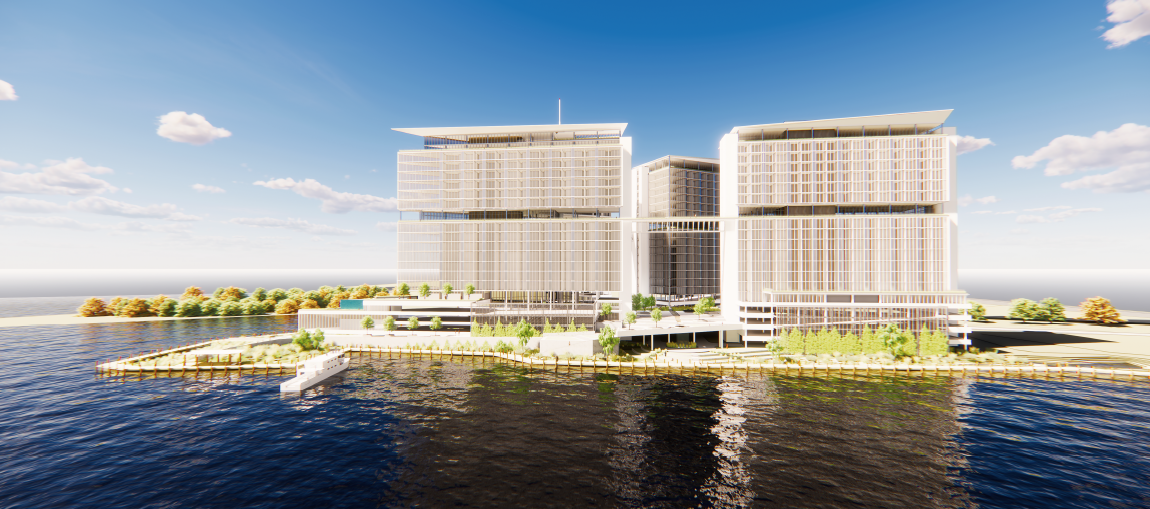
- The specific project does not intend to build any bulkheads other than to replace the existing bulkhead (less than 5% of the shoreline) where a proposed river taxi port could be located. The text amendment specifically specifies a living shoreline with no bulkheads.
- “Project will be a financial burden to city and county residents”: New tax revenue from the 850 residents and businesses of Peter Point would more than cover any additional services required to be provided.
- “…Will only benefit the elite few.” Battleship Point will actually provide over 800 critically needed housing units in a much smaller carbon footprint than many of the current sprawling developments already approved by the Town of Leland, Brunswick County, and New Hanover County.
- “Rezoning and Annexation means approval.” Rezoning and Annexation by any city or town are only the first steps in a long process. Either of these does not indicate approval of the project.
- “A bunch of out-of-town” developers. The members of KFJ Development Group are all local – with more than 90 years of combined history in southeastern North Carolina.
- “Proposed building in wetlands.” To the contrary, less than 50% of the proposed site is wetlands.
- “Why come to Leland when New Hanover County has already said no?” New Hanover County Board of Commissioners has not said, “no.” A decision has been tabled pending further study and discussion.
- “You can’t build in a designated floodplain.” Yes, actually, you can; subject to the regulations and oversight of the appropriate authorities.
- “Only 1 way in and out.” WMPO and DOT have already signed-off on right-in and right-out both North and Southbound – for two points of ingress and egress.
Summary:
New Hanover County, Leland, Brunswick County, and Wilmington, have the opportunity to control the vision for the West Bank. There is also an opportunity to take control of the gateway into Leland, through Wilmington inland, and crossing the Cape Fear River.
Currently zoned heavy industrial, the opportunity for special interest groups, municipalities and the Counties to effect change on the West Bank has existed for decades – with not only no action, but effective disregard for the health and beauty of the West Bank and the confluence of the Cape Fear and NE Cape Fear Rivers.
KFJ Development Group has seen the opinions written by Roger Shew, Kemp Burdette, Dr. Rob Young, the NAACP, Mr. Willis, Dr. Parr, The League of Women Voters, the Historic Wilmington Foundation, and others. All are arguably educated and passionate people. As I understand them, the objections are as follows:
- Sea Level Rise
- Nuisance Flooding
- Storm-event flooding
- Health and life safety
- Preservation of cultural and historical artifacts
- Conservation of community resources in the event of catastrophic events
- Preservation and protection of the floodplain
It is interesting that not a single opponent has stated that the development can’t be built, only that they don’t want it built or that it should be “low-impact” or greenspace.
Dena Prastos, from Indigo River, was solicited by KFJ Development Group specifically for her expertise in this arena.

She is a graduate of the New Jersey Institute of Architecture, with a subsequent degree in Civil Engineering, and a graduate of Harvard Business School’s Executive Education Program. She was also selected to be a member of the 2022 AIA Resilience and Adaptation Advisory Group- and her specific field of expertise is in design, architecture and development in environmentally sensitive areas.
From her feasibility memo, the structural elements of this project (text amendment and annexation) are designed to minimize impacts to navigation and marine life by limiting outward expansion through the project area, based on site conditions. Specifically, the goals are to:
- Cap in place contaminated soil
- Elevate occupiable areas (49’ AMSL)
- Avoid structural encroachment into the Federal Navigation Channel
- Enhance and preserve marshes and wetlands; avoid encroachment into same
- Increase resilience of the shoreline structures for future storms and sea level rise
- Increase recreational river access, and
- Avoid vertical structures that increase wave and wake in the river through amplification and rebound.
Prastos’ conclusion: The site is suitable for development.
- Geotechnically
- No net loss of habitat
- Resilient ecosystems
- Minimal impacts on marine life
- 50,000 square feet of intertidal area developed into healthy ecological habitats
- Adjacent roadway structures are of similar construct
By rezoning in accordance with the proposed text amendment, the economic benefits to New Hanover County, the Town of Leland, or the City of Wilmington for construction in the zone are in excess of $212m annually, assumed for a period of ten years, and holds the potential to create more than 1200 jobs. This economic impact includes direct economic impact of construction as well as the indirect and induced effects (or multiplier effects) resulting from the overall increased economic activity associated with the construction project.
Design will endeavor to avoid, minimize and mitigate the potential environmental impacts by balancing the cut and fill amounts to result in no net loss of aquatic habitat, minimize in-water structures, capping deleterious materials, removing derelict structures, minimizing fill, strategically locating upland piles to support the proposed structures, elevated platforms and elevated walkways; creating salt marshes, tidal pools, and other types of habitats. The project goals and strategies build off the Army Core’s Comprehensive Restoration Plan and prevailing Living Shoreline Guidelines and to align with National, Regional, State and local initiatives along the waterfront.
The proposed text amendment and annexation will result in and require:
Expanded public waterfront access along the Cape Fear River, while enhancing and sustaining habitat and increasing resiliency of the site and upland areas in a manner that recognizes the constraints posed by the navigational waterway. The project, as conceptually designed, maximizes the shoreline resiliency in the context of the site, and augments it with best-in-class building sustainability and resiliency measures. This integrated approach ensures that coastal flooding and sea level rise are mitigated in the near future and can be adapted for the next century.